Erin becomes the season’s first hurricane as it nears Caribbean
Erin, the first hurricane of the 2025 Atlantic season, is on track to rapidly intensify over the weekend and hit Category 4 next week in the open ocean.
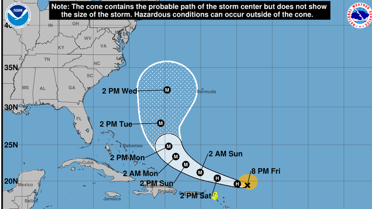
The latest forecast from the National Hurricane Center calls for Erin to cruise west for the next few days — staying comfortably north of inhabited islands — before hooking north early next week and avoiding direct landfall in the Bahamas or Florida.
Islands near Antigua and St. Martin remain under a tropical storm watch, which means tropical storm conditions could occur in the next day or so as the storm passes to the north on Saturday.
Erin is projected to pass north of Puerto Rico and the Virgin Islands on Sunday, and although the storm will be hundreds of miles away, it will be large and powerful enough to cause rough waves and heavy winds on the islands, raising concerns about power outages and mudslides.
By the time Erin passes to the east of Florida, it could be big and strong enough to send rough surf and even rainstorms toward the state, although forecasters said it’s still too soon to tell exactly what the Sunshine State will see. For now, high surf from Palm Beach north and drier — less humid — air is most likely.
READ MORE: Hurricane Erin likely to steer wide of Florida but we may still feel some impacts
“While the threat of direct impacts in the Bahamas and along the east coast of the United States appears to be gradually decreasing, there will still be a significant risk of dangerous surf and rip currents along western Atlantic beaches next week.,” they said in the 5 p.m. Friday discussion.
As of Friday night, Erin was quickly moving west-northwest at 17 mph and had sustained winds of 85 mph, a Category 1 hurricane.
During the weekend, Erin is expected to rapidly intensify to a Category 3 hurricane. By Monday, as the storm steers away from the Caribbean and toward Bermuda, it’s forecast to hit Category 4 with 145 mph sustained winds. Some long-term computer models suggest it could hit Category 5 in the open ocean.
For now, the hurricane center’s forecast track only goes through Wednesday, and it suggests Erin will shoot the gap between the East Coast and Bermuda. Some models suggest the track could veer closer to Bermuda in the coming days, and others inch it closer to the East Coast.
The hurricane center is also eyeing a disturbance near Texas and says it won’t be a named storm before it comes ashore this weekend. It could bring a weekend of heavy rain to Texas.
This story was originally published August 15, 2025 at 8:49 AM.
