Florida could feel outskirts of Tropical Storm Imelda as it crosses the Bahamas
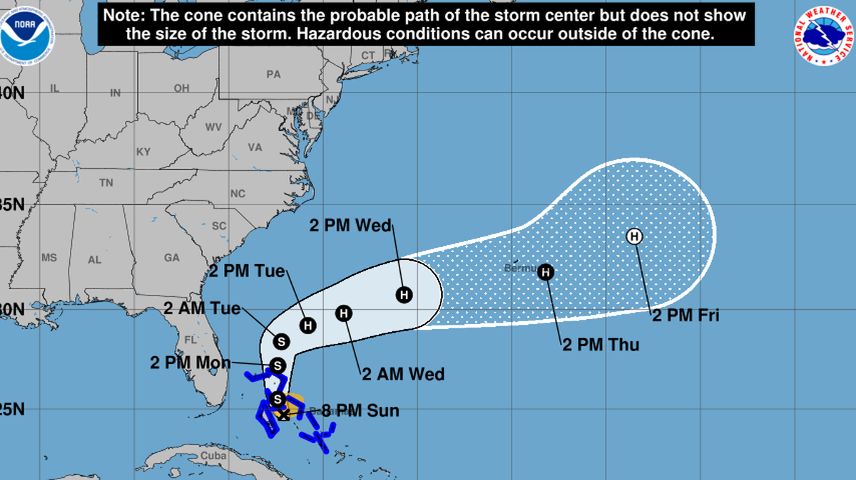
All of Florida’s tropical storm watches, which covered a swath of the East Coast, were rescinded Sunday afternoon as Tropical Storm Imelda’s forecast track continued to nudge further offshore.
However, Florida and the Bahamas will see some rain and blustery winds throughout the day Sunday and Monday from Imelda — with the most intense conditions over the islands, which were under a tropical storm warning.
Much of the Bahamas are expected to be soaked — with six to twelve inches of rain in the heaviest spots near the northwest — and be swept by winds of 45 mph and up as the depression strengthens into Tropical Storm Imelda as early as today.
South Florida is likely to see far less rain and experience weaker winds, as continued updates from the National Hurricane Center moved the forecast track east, keeping its core farther offshore.
The Miami office of the National Weather Service called for “periods of showers and storms throughout the day Sunday” as the storm crawls up the coast.
Ana Torres-Vazquez, a meteorologist at the Miami office of the National Weather Service, said the worst of the system will likely be past South Florida by midday Monday, unless some of the trailing bands of rain and thunderstorms end up sweeping over the region.
“Right now, with the storm remaining further east, it’ll all come down to how those outer areas set up and which way they move,” she said. “It’s still a sloppy mess.”

South Florida is expected to see one or two inches of rain Sunday and Monday, she said. But if those lagging rain bands arrive, some isolated spots could see up to four inches of rain.
“The risk of significant wind impacts along the southeastern United States coast is decreasing, but interests in that area should continue to monitor the latest forecast updates.,” forecasters wrote in the 5 p.m. update.
What’s next?
As of the 8 p.m. update on Sunday, Imelda held a tropical storm status. The last major forecast update included another nudge of the track to the south and east, increasing the distance from the Florida coast.
The latest forecast shows Imelda creeping along Florida’s coast for the next few days — a slowdown from Saturday’s forecast. Imelda is forecast to become a offshore hurricane by late Monday or Tuesday.
That slower track is helpful to residents along the Southeast coast of the U.S., forecasters said, because it allows the weaker, slower Imelda to be influenced by the much more powerful Category 4 Hurricane Humberto.

That explains the sharp right hook in Imelda’s forecast track, instead of a once-predicted landfall in the Carolinas.
However, the hurricane center warned, the storm is large and slow enough that even if it does get yanked out to sea it will likely dump a ton of rain on coastal swaths of the region.
This story was originally published September 28, 2025 at 8:24 AM.
