Tropical storm watch issued for Florida Keys ahead of potential west coast landfall
The Florida Keys and much of Florida’s west coast are under a tropical storm watch as a messy tropical wave rolls over Cuba and toward the state.
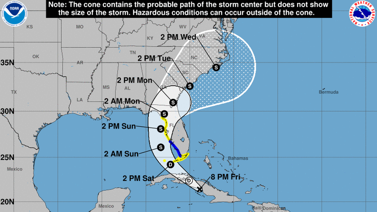
The National Hurricane Center released its first cone for the potential tropical storm Friday morning. The track shows the system crossing over the Keys on Saturday, curving into the Gulf of Mexico on Sunday and making landfall north of Tampa Bay on Monday.
It is expected to strengthen into Tropical Storm Debby as soon as Sunday.

On Thursday evening, Gov. Ron DeSantis declared a state of emergency for most of the counties in the state. South Florida wasn’t included, although the National Weather Service’s Miami office has warned there could be heavy rainfall that could cause flooding this weekend.
Through Monday, South Florida could see at least 4 inches of rain, with the highest levels in the state felt north of Tampa Bay at around 12 inches. Key West could see up to 6 inches.
The Keys, Tampa Bay and Charlotte Harbor could see up to three feet of storm surge.
As of 8 p.m. Friday, the hurricane center said the system was about 285 miles southeast of Key West and headed west-northwest at 16 mph with maximum sustained winds of 30 mph.

Forecasters with the hurricane center said it wasn’t clear exactly where the storm could make landfall in Florida, and that potential spot might shift in the coming days.
“Since the forecast track is almost parallel to the west coast of the Florida Peninsula and the southeast coast of the U. S., only a small change in the track could lead to large changes in which land areas receive any landfalls and the biggest impacts,” they wrote.
Hurricane hunters are scheduled to fly into the tropical wave, currently located over eastern Cuba, later Friday. Their data will help inform the models that predict where the storm will go.
Once the system emerges into the Gulf of Mexico, where waters are warmer than average, the hurricane center said it is likely to steadily strengthen into a tropical storm. The longer it takes to strengthen and move across the state, the more rain could fall on Florida.
“The two biggest uncertainties in the intensity forecast are how long the system will remain offshore of Florida and how long it will take to consolidate,” forecasters said.
This story was originally published August 2, 2024 at 8:12 AM.
